OKWEATHERWATCH STORM CHASE 2011 – SEASON 30
17
Days – 4777 Miles
All
times CDT
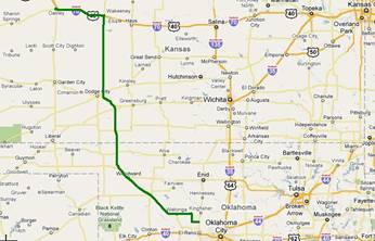
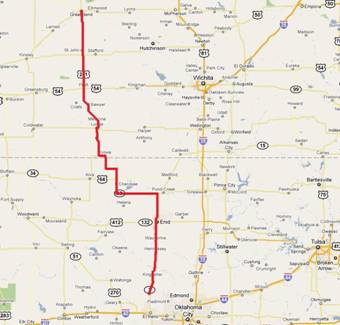
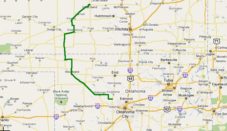
Chase Day #17
June 11, 2011 /
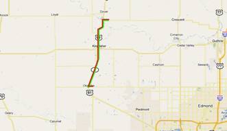
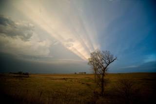
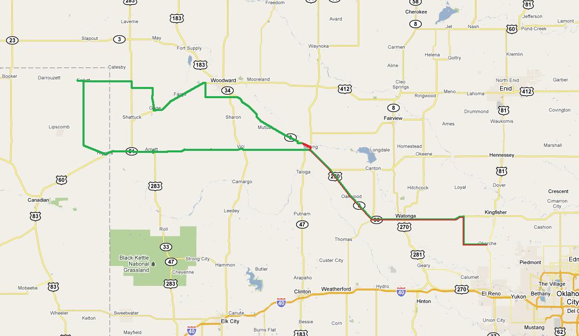
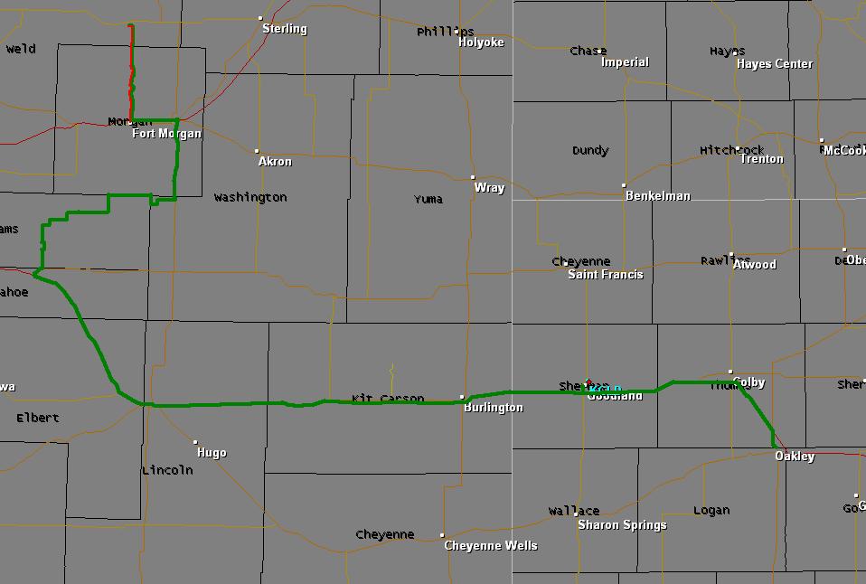
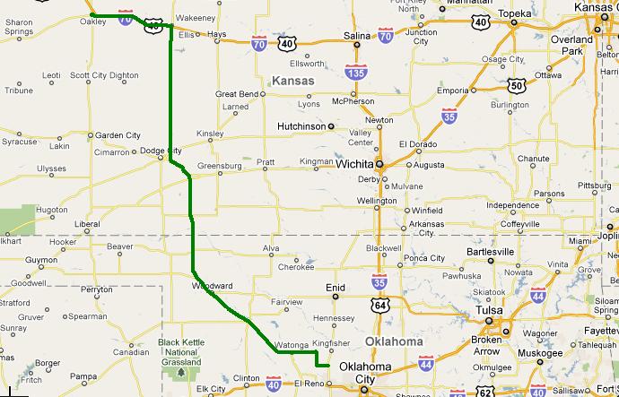
11-17 / DS / 132557-132880 / 323 / 1:59 p.m. / 10 hr 18 min / OK,TX / Gallery - Map
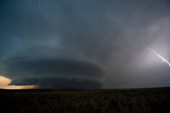
1
- Monster supercell storm moves into northwest Oklahoma from the Texas
panhandle.
It took a long time, but the storm of the season finally
showed up. There was a very large
threat area which extended from eastern Colorado
into Oklahoma, but we felt that one of the
best places to be was over the northeast Texas
panhandle / eastern Oklahoma panhandle and
extreme northwest Oklahoma. High surface dew points were moving
northwest on strong southeast low-level flow and a northwest to southeast
surface boundary was retreating northward. There was sufficient mid-level flow
producing shear profiles supportive of rotating storms.
We worked out way northwest to Arnett, Oklahoma
watching several areas of developing storms in the region. While some of this looked well organized
at times, we continued to stay focused on our original target. A storm starting
getting organized in southeast Ochiltree
County just after 5 p.m. We decided that this was our first
target storm and we started driving toward Follett,
Texas as the storm entered Lipscomb County.
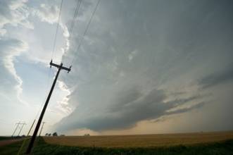
The storm appeared LP in nature both visually and on radar,
becoming severe over northwest Lipscomb
County. Structure steadily improved, becoming
very impressive as the storm became rooted over northern Lipscomb County
– moving only about 5 M.P.H. to the east. The storm eventually became strong
enough to start ingesting other weaker storms from its west and south. This process may have caused the storm
to both transition to more of a classic supercell,
and increase its tornado threat. We
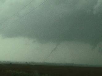
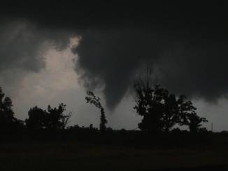
noted more than one area of strong rising motion and rotation before a tornado
developed about three miles northwest of Follett. It was embedded in rain, but we were
able to see several vortices at the ground for a couple of minutes starting at
7:49 p.m.
Just after this tornado weakened, a close examination of
radar showed that a new storm was rapidly developing along its south flank –
or basically, on top of us. We fled
east through Follett and into Oklahoma,
driving through the developing new core.
This storm intensified extremely rapidly and we noted strong areas of
cloud base motion / rotation as we crossed quickly into Oklahoma. After we cleared the storm, we carefully
worked our way east and southeast ahead of it taking the time to stop several
times and shoot pictures of the incredible storm structure. Overall, this storm looked downright
mean. Low-level flow was screaming
into the storm, which was now clearly HP, and lightning was shooting out of
just about every place it could come out of the storm.
Storms this impressive are few and far between. We were quite happy with our interpretation
of the day, our reactions, and our results. The storm started to weaken
significantly when we were near Seiling and this left
us with only a short ride back to Okarche.
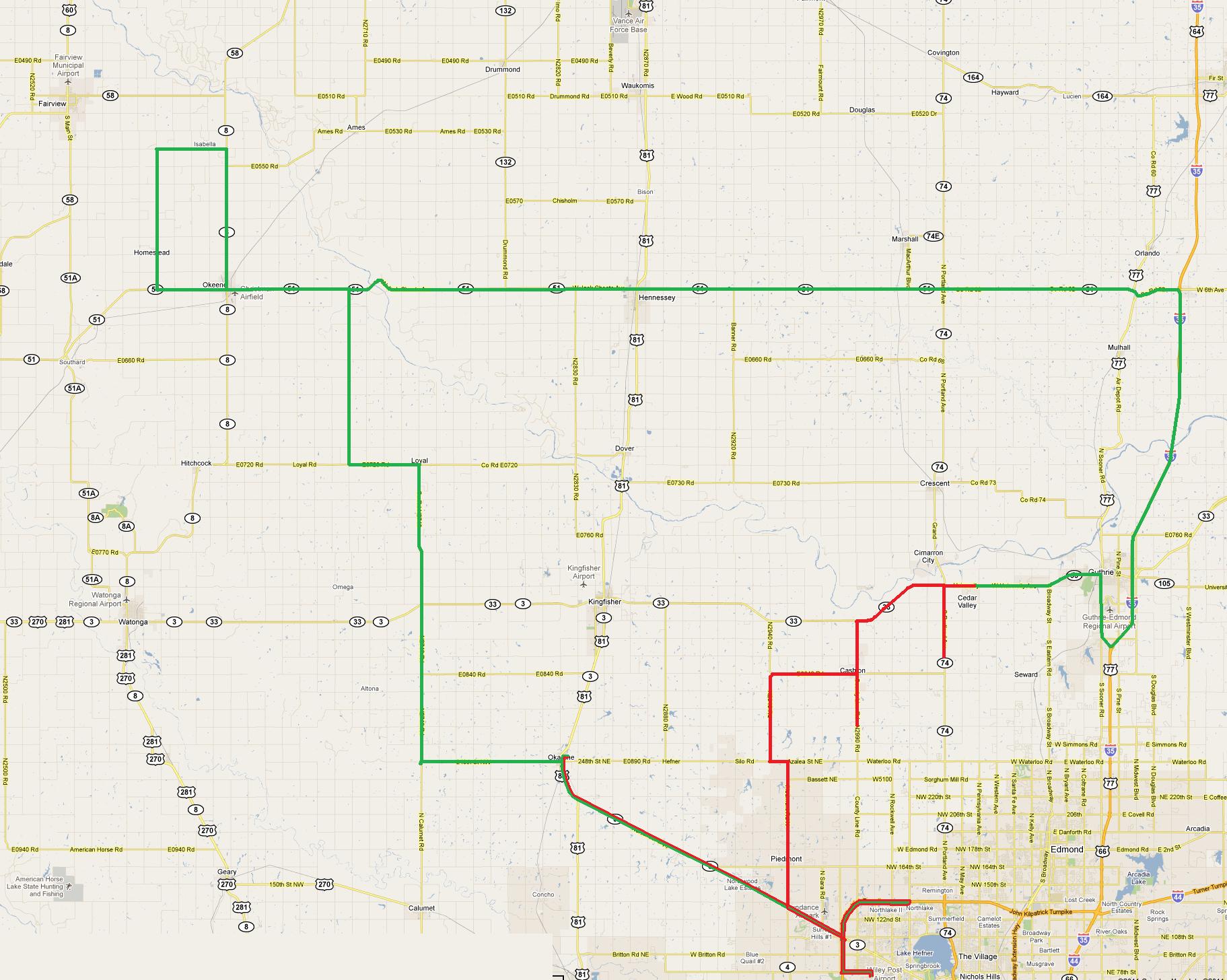
Chase Day #16
June 10, 2011 /
11-16 / NONE / 131954-132512 / 558 / 10:24 a.m. / 11 hr 25 min / CO,NE,KS,OK / Gallery - Map
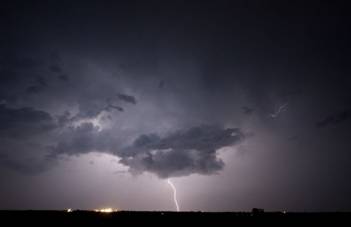
2
- Thunderstorms produce cloud to ground lightning near Cashion, Oklahoma.
With limited lightning in the high plains over the previous
few days, and a decent amount of lightning with storms in Oklahoma, we made the decision to head back
south. The only trouble was the
fact that we woke up in Julesburg,
Colorado. We were just barely into extreme
northwest Oklahoma when storms rapidly formed
in Kingfisher, Blaine and Canadian Counties. Needless to say, we didn’t catch
up with those. We were treated to
other storms which formed in the wake of the original activity that gave us a
few nighttime lightning opportunities around the Okarche area.
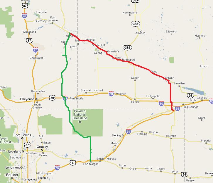
Chase Day #15
June 9, 2011 /
11-15 / NONE / 131667-131954 / 287 / 1:03 p.m. / 10 hr 41 min / CO,WY,NE / Gallery - Map
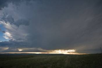
3
- Thunderstorms near Chugwater, Wyoming.
This didn’t turn out to be a very exciting day. We left Fort Morgan early in the
afternoon and drifted northwest to Burns, Wyoming where we spent about five
hours parked in the same place – throwing rocks at various targets and
watching storm attempts fail one right after the other. Around 6 p.m. MDT, a line of storms
formed over central Platte and northwest Laramie Counties. For a brief time, a couple of the storms
looked supercellular on radar. This didn’t last long however, the
storms gradually weakened as they moved east and spread over cooler surface
air. With limited lightning and
structure, and the plan of getting to Oklahoma
the next day, we called it over and made our way to Julesburg, Colorado.
Chase Day #14
June 8, 2011 /
11-14 / NONE / 131334-131667 / 333 / 11:48 a.m. / 12 hr 11 min / KS,CO / Gallery - Map
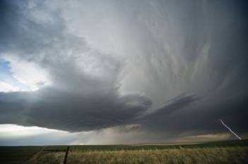
4
- Eastern Colorado
superell produced cloud to ground lightning.
I met up with Pete, Steve and Ester in Byers, Colorado where the
target was a fairly small one.
Despite dew point temperatures in the low 40’s, steep mid-level
lapse rates and favorable shear profiles were expected to support a couple of supercell storms in an upslope flow regime. We were not disappointed.
Cumulus began developing early over the mountains and
struggled through most of the afternoon.
This one was going to take a lot of patience. Numerous failed storm attempts were
producing a lot of virga as they spread overhead
during the late afternoon. Still, I
thought that we would be able to have a supercell
evolve out of the mess. That one
storm that I was looking for formed just after 6 p.m. MDT over the east side of
DIA. We followed it northeast
across Adams and Morgan
Counties for over two
hours. Lightning was limited, but
storm structure at times was quite impressive. The storm weakened rapidly over northern
Washington County
just after 8 p.m. and we spent the rest of the evening watching lightning in Weld County
before stopping at Fort
Morgan for the night.
Chase Day #13
June 7, 2011 /
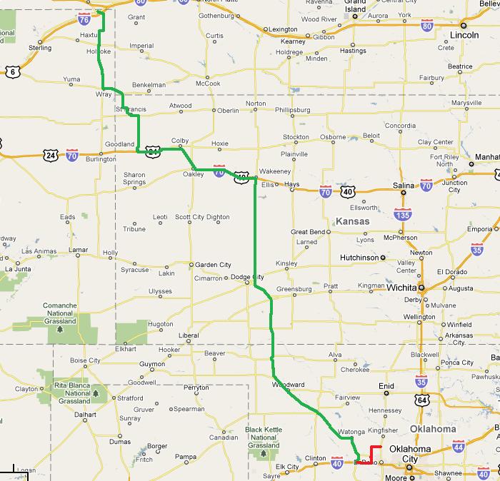
11-13 / NONE / 130983-131334 / 351 / 2:29 p.m. / 6 hr 45 min / OK,KS / Map
Just a travel day that landed me in Oakley, Kansas. Plan is for upslope storms the next few
days in eastern Colorado
and adjacent areas of Wyoming/New Mexico.
The intense smoke plume from Arizona
wildfires scares the hell out of me.
If it shifts north, photo opportunities will be greatly reduced.
Chase Day #12
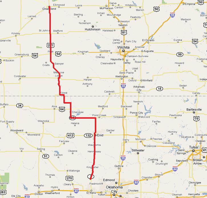
May 31, 2011 /
11-12 / DS / 130333-130556 / 223 / 10:48 a.m. / 4 hr 51 min / KS,OK / Map
Travel day back to Okarche – but a little on the
surreal side for us. We
hadn’t been on the road long before coming across tornado damage about
nine miles south of Great Bend. We first thought that the damage looked
recent enough to believe that it was associated with the storms we had roll
through the night before. Looking
closer, the dead vegetation was a little older than that and we ended up
tracking down information that it was related to a tornado which occurred on
the 24th of May (same day as the violent Oklahoma tornadoes). Diving into the information further, we
found out that two fatalities occurred in the driveway of the residence we
stopped at. A vehicle containing a
family of three people was driving south on Highway 281 when they were
confronted by the tornado. They
stopped in the driveway and took shelter behind some large trees. Unfortunately, one of the trees fell on
the vehicle killing the woman who was driving and her 16 year old son. Their 21 year old daughter/sister was in
the back and survived – but apparently sustained serious injuries. The deceased were residents of St. John, Kansas
which is located about 16 miles south of where they encountered the
tornado. We were still in the
process of discussing what they encountered – what they must have thought
– and what actions they took when we came to the St. John cemetery. Numerous law enforcement vehicles were
providing traffic control for the funerals of the two tornado victims. All in all, we had a rapid fire flood of
events which quickly brought to our attention the harsh reality of the impact
tornadoes have on people. It has
been brought up ad nauseam, but for all the beauty that storms provide –
we really do want them to see them stay away from people.
Chase Day #11
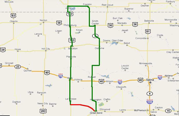
May 30, 2011 /
11-11 / DS / 130018-130333 / 315 / 11:09 a.m. / 10 hr 5 min / KS,NE / Gallery - Map
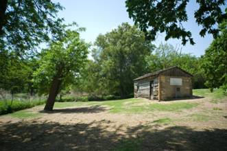
5
- "Home On The Range"
We had fairly high expectations on the day – not only
were there likely to be supercells in Nebraska, but we thought a few could form in
northwest/north central Kansas
as well. We left Great
Bend and moved toward Alma, Nebraska taking the time to stop in a couple of small
towns and at a cabin site in Smith
County, Kansas. This cabin was the home of Dr. Brewster Higley – who wrote the words to what would become the
Kansas state
song. The poem was titled My Western Home – you might know
it more as Home On The
Range. When you look at all the
lyrics of the poem – and see where he lived for 25 years, you can
certainly understand where he got his inspiration. At the same time, a few of the lines
suggest that he was suffering at times from cabin fever – or some other
kind of fever. We found it to be,
well – small. Still, it was
an entertaining stop and we then continued our trip north.
Most of our model guidance gave us hope that storms would be
within reach, but appeared to greatly underestimate the strength of the
cap. We were suckered in on several
weak attempts at storms, but in the end, had nothing more than another pretty Kansas sunset along our drive back to Great Bend.
Chase Day #10
May 29, 2011 /
11-10 / DS / 129733-130018 / 285 / 3:31 p.m. / 6 hr 20 min / OK,KS / Gallery - Map
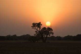
6
- A little smoke enhances the Kansas
sunset.
We left Okarche mid-afternoon and headed northwest
eventually reaching Buffalo. “Storms” had formed in the
northeast Texas panhandle and were moving
toward far northwest Oklahoma. We didn’t expect much out of
them, but hoped that they would provide us some lightning photo opportunities
as we made our way toward Kansas/Nebraska for what was to be a better following
day. We didn’t expect much
– and didn’t get much.
In fact, there were only a couple of times that we “thought”
we saw lightning. We did break out
the cameras for a couple of stops at an abandoned house and for the sunset
before reaching Great Bend,
Kansas.
Chase Day #9
May 28, 2011 /
11-09 / DS,ME,JA /
129696-129730 / 34 / 7:08 p.m. / 1 hr 22 min / OK
Just about not worth putting down. We watched all day as towering cumulus
worked to become storms just to our northwest. We waited until one did – which
became severe warned – and we headed north to intercept it near Dover. The strong capping won out and our storm
looked bad by the time we got there and was just about gone a short time
later. The cameras never came out
of the bags.
Chase Day #8
May 24, 2011 /
11-08 / ES,PA /
129112-129415 / 303 / 12:58 p.m. / 8 hr 31 min / OK / Map
7-
Tornado just southwest of Fairview,
Oklahoma.
High risk day with typical high risk blues. We knew this would be a big tornado day
in Oklahoma, but
what usually comes along with that are fast moving storms. Our initial target storm took us too far
to the northwest to recover for what was to be the storm of the day in Canadian County. We missed the largest tornado near Canton Lake,
but saw a brief tornado near Fairview. Afterward, we made a hard attempt to get
in front of what was the big tornado producer. We drove quickly east to I-35 and south
to Guthrie. We should have been
rewarded with a nice looking tornado for our efforts and the overall way we
played connecting with this storm, but instead, found ourselves playing with a
very wet, rain-wrapped tornado as it moved through the northwest side of
Guthrie. We knew a tornado was
there by the radar display and the quick wrapping motion in the precipitation
(along with falling debris) – but seeing anything similar to a tornado
was virtually impossible. We called
it a day at that point and spent the next hour+ trying to find a way across the
damage path to get back to northwest OKC.
Chase Day #7
May 23, 2011 /
11-07 / ME,PA /
128960-129112 / 152 / 2:35 p.m. / 4 hr 25 min / OK / Gallery
8
- Supercell just southwest of Okarche was producing
hail nearly baseball size.
Our chase kept us pretty close to home – in some ways
– too close. Storms had
already formed in west central Oklahoma when
we departed to the northwest, expecting additional development in northwest Oklahoma. Widespread storms blew up around 3:20
p.m. from Grant County
to Custer County. We adjusted our route slightly and
worked into northwest Kingfisher County where we watched a severe storm get organized
over northern Blaine and southeast Major Counties. This storm produced a brief tornado in
northern Blaine County. It was quite a distance from us and we
were unable to see debris on the ground despite observing a well organized
funnel cloud. Media spotters closer
to the tornado could see debris on the ground with this feature.
The storms quickly became a “messy blob” over Garfield and Major
Counties and we started moving south
toward more isolated storms forming in Kingfisher and southern Blaine Counties. A well organized supercell
– with quite impressive structure – formed about 15 miles west of
Okarche. The storm wobbled in its
movement to the southeast and east and produced large hail within a mile of the
house. There also appeared to be a minor
tornado threat with the storm as it approached Okarche. When the storm started a rapid weakening
trend – we returned to the house and were home by 7 p.m.
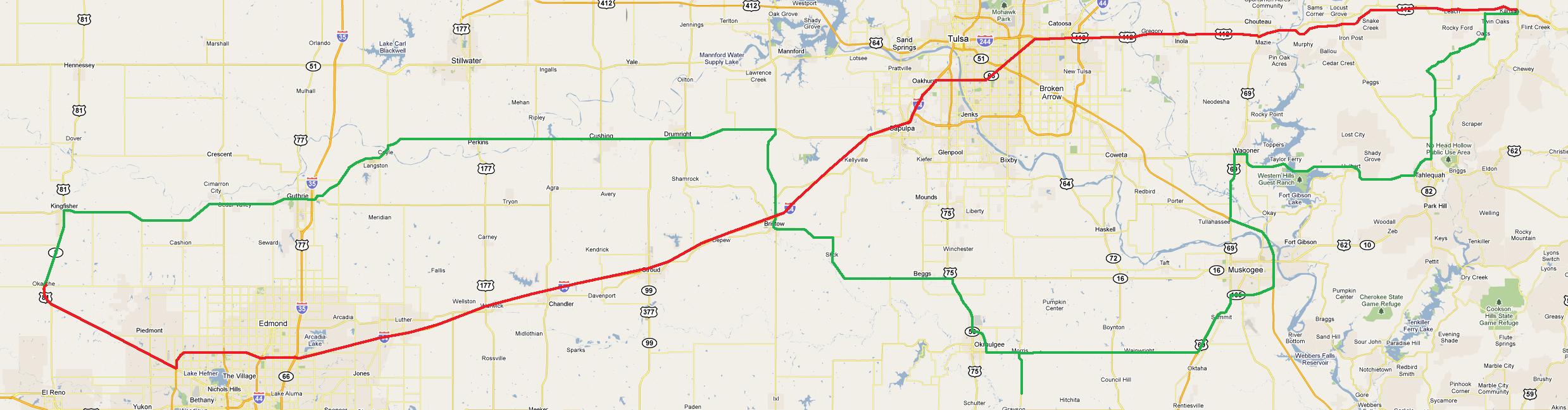
Chase Day #6
May 22, 2011 /
11-06 / NONE / 128502-128960 / 458 / 2:08 p.m. / 9 hr 59 min / OK / Gallery - Map
9
- Tornado north of Oaks in Delaware
County, Oklahoma -
around 8:20 p.m.
Parameters looked similar to the previous day when supercells produced tornadoes in south central Oklahoma. Not a lot of forcing, but big CAPE and decent shear. Afternoon heating and dry line
convergence was expected to be sufficient to form storms.
Normally not an eastern Oklahoma
chaser, I didn’t think I would have to stray far – maybe eastern Lincoln or Payne Counties – but each passing mile pulled me
farther and farther into the eastern Oklahoma
abyss.
The first target storm attempted to form in eastern Okfuskee County
and I pulled along the east side of it near Okmulgee just after 5:40 p.m. This storm struggled from the
start. It had a few interesting
features but was very much on the anorexic side of things. While watching this storm fight to grow,
there was explosive growth in a CB to my north northeast. This storm was forming near the southeast
Tulsa/Wagoner County line and was close enough to become my new target
storm. It didn’t take much
drive time farther east before what had been good visibility steadily went
downhill due to haze.
I literally stumbled up on the business end of the storm
near Moodys in Cherokee County. Driving through trees, hills and haze,
the updraft region of the storm suddenly appeared to my northwest around 7:30
p.m. There was a lot of rising
motion and some rotation – enough so that I thought a tornado was still
possible. It appeared to become
somewhat disorganized and strung out from that point on as I made my way up the
west side of the storm toward Oaks.
I had pretty much accepted defeat just before 8 p.m. and started
planning my route back to Okarche.
While planning my route back, there was an obvious increase
in lightning overhead and just to my north. The sky was cluttered, but radar showed
a rapidly increasing storm just to the northwest of the previous one. I got a few big rain drops on me when I stopped
at a gas station just north of Oaks along Highway 412. The updraft was just to my west and only
interesting enough for me to make a mental note to check it out when I got
through inside the station. With
Diet Coke, chips and ice in hand, I was more than a little surprised to see
what I saw as I went back to the parking lot. There were some trees in the way, but in
all likelihood – a tornado was already occurring to my west. I dropped everything in the car and
grabbed the video camera and moved to the northwest side of the building.
Times are good / Locations as always are best guesses:
8:17-8:25 p.m. – from 2 northeast of Leach to 3.3 west
northwest of Kansas in Delaware County
– about 2.3 miles long
8:29-8:30 p.m. – about 4.5 west northwest of Kansas in Delaware
County – about a
mile long
It was getting dark and I didn’t attempt to follow
this storm even though it appeared to be capable of producing further, and it
was also likely associated with a possible large tornado which later occurred
near Gentry, Arkansas. I stopped
for a little lightning photography near Locust Grove and made it home shortly
after Midnight.
Chase Day #5
May 19, 2011 /
11-05 / NONE / 127986-128271 / 285 / 1:08 p.m. / 6 hr 11 min / OK / Gallery
10
- Slowly rotating wall cloud near Butler,
Oklahoma.
The decision to stay in Oklahoma
was largely based on the rumored number of chasers which were headed to Kansas. Yes, it’s sad that it’s come
to this, but shear numbers of chasers on the roads do make an impact on chase
decisions. Still, I thought that Oklahoma had a decent shot of seeing tornadoes, and it
appeared that would come true given the early start of supercell
storms in southwest Oklahoma. What I forgot was that I’ve never
really had a good day when storms get going so early. The only somewhat impressive storm I
came across was in Custer
County. There were two brief periods where the
wall cloud was rotating enough to hold my interest. By the time the storm moved into Dewey County,
it looked as if it had become decoupled from the surface and appeared fairly
high based. I dropped back
southeast toward storms that were moving toward the Oklahoma City area and met the leading edge
near Minco. These storms were
totally uninteresting – the sky had more of a winter look than a severe
weather look. I could have made an
attempt at catching anvil crawlers out of the front of the storm, but the sky
had absolutely no contrast to it and I made my way back up Highway 81 to the
house.
Chase Day #4:
May 18, 2011 /
11-04 / DS / 127852-127986 / 134 / 3:56 p.m. / 4 hr 14 min / OK / Gallery
11
- We passed this old house once and decided to stop on the second pass. It sits on the east side of Highway 51a
- several miles north of Watonga.
This day was expected to be a lot more and we got a lot less
than some of the previous chases so far this year. Doug and I left the house on a fairly
short trip to the dry line which was just west of Highway 81, where supercell storms were expected to develop. There was high instability and excellent
shear in place – and bubbling along the dry line when we left. The CU and TCU started going rapidly
downhill shortly after we departed and a dense layer of high clouds overspread
our target area. One small CB was
evident to our northwest for a time and produced an echo on radar, but weakened
about as quickly as it appeared. We
spent a few hours driving some back roads in the area on the way back which
provided a few photo opportunities – otherwise, the lackluster severe
weather season continued its pace.
Chase Day #3:
May 8, 2011 /
11-03 / NONE / 127131-127194 / 63 / 6:05 p.m. / 1 hr 53 min / OK / Gallery
12-
Weak storm in eastern Canadian
County.
Not a lot expected of the day. Scattered storms formed in southwest Oklahoma and moved
toward the metro area. I took a
short drive to Minco and picked up a high-based storm that provided a few photo
opportunities as it moved through eastern Canadian County.
Chase Day #2:
April 14, 2011 /
11-02 / NONE / 125385-125850 / 465 / 9:30 a.m. / 10 hr 52 min / OK,KS / Gallery
13
- Tornado warned storm looking west from about 8 miles southwest of Bowring, Oklahoma.
My starting place for the day was based totally on the fact
that I didn’t want to be chasing in eastern Oklahoma. I know it’s been covered over and
over before, but hills, trees, lakes and bad road options are not your friend
when you are trying to navigate a supercell
storm. Given the fact that storms
would become established east of I-35, I thought I would counter the problem by
going to Kansas
where the landscape is a little less hostile.
One thing that wasn’t forgiving was the amount of time
it took to get decent moisture north of the Kansas/Oklahoma border. By 3 p.m., my decision had been made
that if I wanted to see good storms, I would have to drop south into Oklahoma - more specifically, Osage and Washington Counties. There are a couple of places to view
from. I did say a couple. Once I used those up, it was back to the
hills, trees and lakes.
To be honest, the storms looked the best at one of my better
viewing areas looking across Lake
Hulah. In the end, a typical combination of
smoke, haze and mushy storms didn’t excite me. After driving around Lake Copan
and through a couple of towns that it looked like time forgot, I returned to Kansas for one final
swing for the fence at a tornado warned storm. I found it in worse shape than when I
left it and turned the car toward home.
I always seem to have to make one eastern Oklahoma trip each year to remind me why I
don’t go that direction very much.
Chase Day #1:
April 8, 2011 /
11-01 / DS,PA /
124803-125011 / 208 / 5:10 p.m. / 5 hr 53 min / OK / Gallery
14
- The sun shines under the anvil of our severe storm a few miles north of Lahoma.
The proximity of the severe threat allowed us to sit at the
house in Okarche for much of the afternoon and monitor weather trends. Between 3 and 5 p.m., we watched as a
persistent area of towering cumulus spread out of southwest Oklahoma – toward the north central
part of the state. As time passed,
a concentrated area of interest moved from south to north, just west of
Okarche, and finally started becoming a storm in northern Kingfisher County.
We departed northbound shortly after 5 p.m. with our initial
target storm near Hennessey. This
storm moved quickly into the Enid area by 5:45
p.m., and we started to believe that we would have issues getting through Enid while trying to run
it down. At this point, we began to
consider changing our target to storms which were getting organized in eastern
Dewey and northern Blaine
Counties. On the south side of Enid, we made the decision to change
direction and worked our way around the southwest side of the city.
By 6:15 p.m., our new target storm had become severe over
the extreme northwest corner of Blaine
County. We observed this storm from a few miles
south of Meno and at another stop about a mile north
of Lahoma.
It sent off a strong left split and looked a bit disorganized at times,
but always had enough shape and lightning to hold our interest.
While in Grant
County, around 8:45 p.m.,
our storm became rooted and rapidly intensified. We drove through core along Highway 11
toward Medford,
encountering hail up to golfball size. It was after sunset, which made it hard
to see, but we were able to identify a well developed funnel cloud just west of
Medford which
persisted for about two to three minutes.
Wrap-around core was beginning to spread east across Highway 81 and we
retreated southward. For several
miles in and south of Medford,
we encountered large hail – up to tennis ball size.