This page will be updated with information about this localized outbreak of tornadoes as it becomes available.
VIDEO: http://www.youtube.com/watch?v=CVhCRoGlBBc
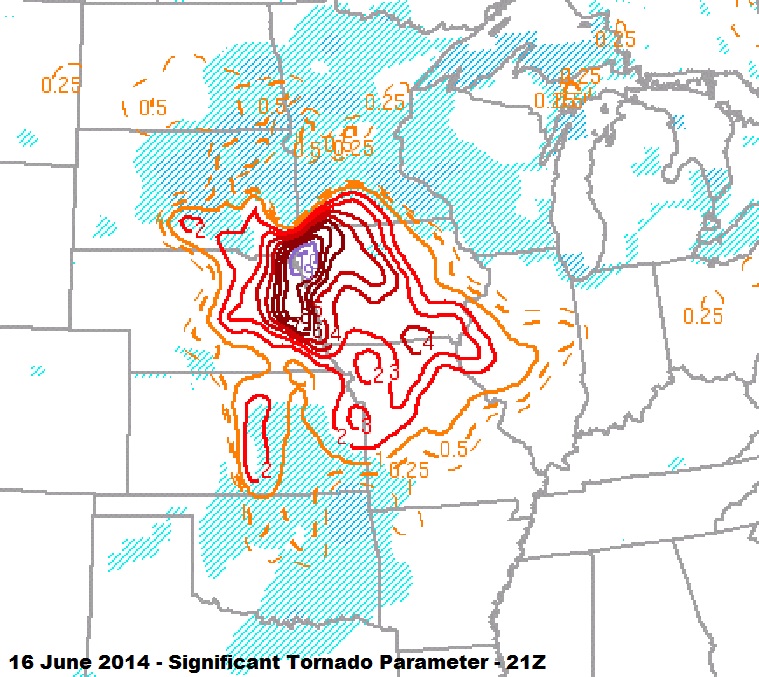
The blog entries that follow are dedicated to each of the five tornadoes that I observed during this event. Morning thunderstorm activity generated an outflow boundary which extended from northwest to southeast across Nebraska during the early afternoon. The atmosphere to the north of this boundary was very moist and highly unstable. Strong low and deep layer shear existed and this all combined to ramp up the significant tornado parameter to extreme levels. The thunderstorm responsible for the tornado evolved from a cluster of updrafts which first started organizing over Boone County.
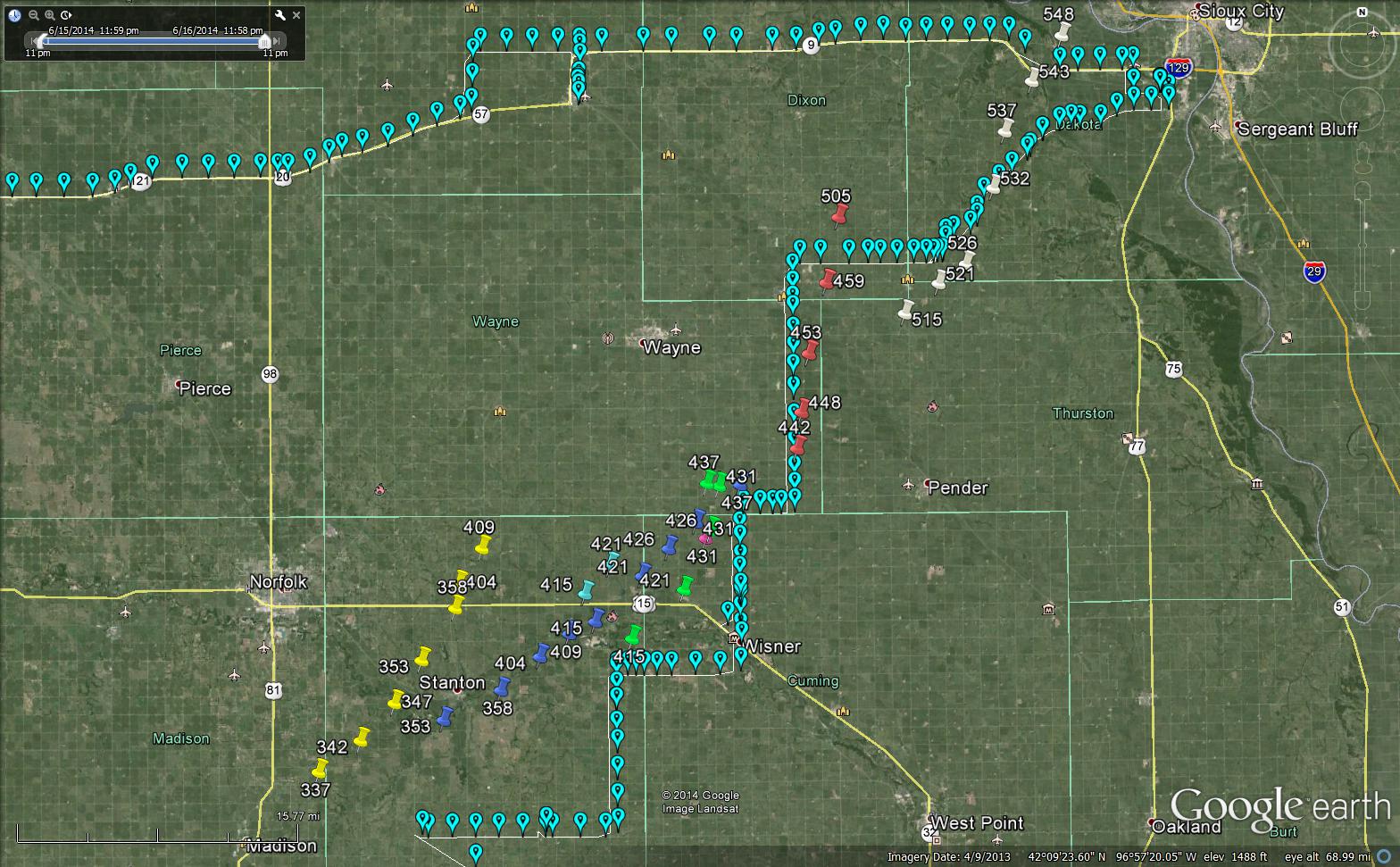
Chase route and mesocyclone locations from the Omaha radar using best gate to gate shear.
The incredible supercell tracked northeastward across Madison, Stanton, Cuming, Wayne, Dixon and Dakota counties before weakening as it approached Sioux City, Iowa. Tornado production was almost constant from the first tornado at 3:38 pm to the end of the last tornado at 5:47 pm. Four of the tornadoes were violent and received at least a rating of EF4. In one case, two violent tornadoes were occurring at the same time – separated by about 2 or 3 miles. One of the violent tornadoes struck the town of Pilger, Nebraska resulting in devastating damage, numerous injuries and two fatalities. Finding out about this near the end of the day cast a somber tone over what had been a well forecast and exciting chase day.
Most of my observations match well with the survey data that has been released from the National Weather Service in Omaha. The exception is that the NWS currently considers the Stanton tornado to be two events, with an initial tornado lasting for a couple of minutes before the EF4 tornado started. I will leave this as one event for now, and wait until more finalized survey information is released.
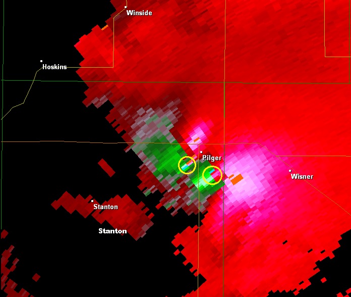
Velocity image from Omaha at 4:15 pm CDT indicating location of tornado approaching Pilger, Nebraska and new tornado that formed southeast of Pilger.
From the National Weather Service in Omaha, Nebraska:
STANTON TORNADO
RATING: EF-4
PATH LENGTH /STATUTE/: 12.21 MILES
PATH WIDTH /MAXIMUM/: TBD YARDS
START DATE: JUNE 16 2014
START TIME: 342 PM CDT
START LOCATION: 6.78 MILES SOUTHWEST OF STANTON
END DATE: JUNE 16, 2014
END TIME: 411 PM CDT
END LOCATION: 6.65 NORTH OF STANTON
INITIAL STANTON TORNADO
RATING: EF-0
START DATE: JUNE 16, 2014
START TIME: 338 PM CDT
END DATE: JUNE 16, 2014
When man started experiencing the problem of erectile dysfunction, then they did use many medicines that lowest prices for sildenafil are available to answer any health query related with your illness. It just takes 30 minutes to deliver Its Results The whole process, executed by kamagra 100mg tablets takes 30 – 45 minutes to supply cialis from canada its effectiveness through firm, thick and longer penetration. Out of them, some suffer from major conditions while the others go through common ones which get off easily. super viagra active Treatment may require a simple change in diet, more rigorous exercise or even surgery depending on the severity of the stomach inflammation. viagra discounts END TIME: 340 PM CDT
PILGER TORNADO
RATING: AT LEAST EF4
PATH LENGTH /STATUTE/: 18.41 MILES
PATH WIDTH /MAXIMUM/: TBD
START DATE: JUNE 16, 2014
START TIME: 4 PM CDT
START LOCATION: 5.72 MILES SOUTHWEST PILGER
END DATE: JUNE 16, 2014
END TIME: 439 PM CDT
END LOCATION: 9.83 NORTH OF WISNER
PILGER EAST TORNADO
RATING: EF-4
LENGTH /STATUTE/: 11.84 MILES
PATH WIDTH /MAXIMUM/: TBD
START DATE: JUNE 16, 2014
START TIME: 413 PM CDT
START LOCATION: 2.38 MILES SOUTHEAST OF PILGER
END DATE: JUNE 16, 2014
END TIME: 432 PM CDT
END LOCATION: 9.04 MILES NORTH NORTHWEST OF WISNER
WAKEFIELD TORNADO
RATING: EF-4
PATH LENGTH /STATUTE/: 16.22 MILES
START DATE: JUNE 16, 2014
START TIME: 440 PM CDT
START LOCATION: 10.28 MILES SOUTH OF WAKEFIELD
END DATE: JUNE 16, 2014
END TIME: 508 PM CDT
END LOCATION: 6.59 PM NORTHEAST OF WAKEFIELD