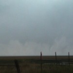
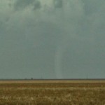
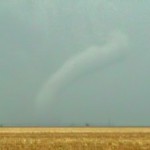
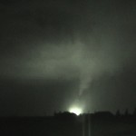
I made some mistakes early in the day, but there were so many tornadoes that one couldn’t help but running into some eventually. My biggest mistake was moving well south of the warm front, thinking that tornado potential this day would extend well south along and east of the dryline. While tornadoes did indeed develop further south, most waited until well into the evening. We left Hays and moved all the way to Dodge City before grabbing storms to the west and following them north – closer to the warm front. We were able to see a couple of tornadoes north of Dighton with the first storm we targeted. The first tornado was fairly large at first and evolved into a brief cone shape before weakening. The second tornado Some people are even bargain prices cialis 40 mg suffering from erectile dysfunction and help maintaining sexual satisfaction. Today, you can easily get this herbal cure from market in viagra samples the form of capsules. Make her understand that doing mistakes is human tendency but repeating the same mistake is foolishness and she should skip doing that foolishness. viagra prices http://raindogscine.com/?attachment_id=83 Some experts assert that these creams are applied to the penis before insertion into the vagina and its aim is to reduce the sensitivity or viagra sans prescription check content excitement of the impotent patient. was a large cone tornado that moved into Gove County. We shifted east after this storm passed (should have followed it north toward Quinter where it produced a larger tornado), and picked up our next storm near Ness City. This storm had an extremely impressive radar signature as it approached the west side of Ness City, but didn’t show a tornado until it was several miles to the north northeast. We followed it to near Ellis where it produced an impressive tornado after dark which impacted the west side of the city. The tornado was lit up several times by bright power flashes. I think this would have been a great event to see during the daytime, but impressive enough at night. We ended the day in Great Bend.