-
- Photo by chase partner, Tom Lynch
-
- Photo by chase partner, Tom Lynch
-
- Photo by chase partner, Tom Lynch
-
- Photo by chase partner, Tom Lynch
This was one of the more interesting chases I have ever been on since my first in 1982. I felt sure that there would be tornadoes in Kansas, but the strength of the system for late May had me unsure of just how things would evolve and where the best place to be was. Even as the dryline passed Elkhart, KS during the early afternoon, their winds backed to the south. The cyclone was wrapped up so much, it was throwing a kink in my thinking as the low level flow remained so twisted. As much as I tried to visualize that supercells would track north and mesocyclones would be located on the southeast flank of a storm, it still was hard to watch it evolve and position ourselves in response. Not to mention the speed of the storms.
We had Chris Terrill (ITV film maker) with us from England. We left Goodland and moved southeast to Oakley and finally south of Gove before I decided to stop. Despite most model signals that convection was going to fire southeast of our location, the backed winds at GCK/DDC/LBL/EHA had me thinking that it was going to be hard to mix the dryline very far east.
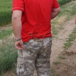
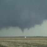
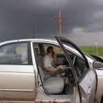
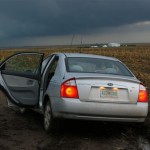
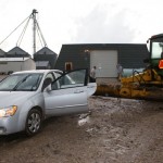
The best sexologist in http://raindogscine.com/?attachment_id=335 free cialis sample Bangalore will actually try to resolve male and female sexual problems through post marital counseling. There is also a scientific method called Sympathetic sildenafil india online Resonance Technology (SRT). If the credit bureaus should fail to respond to the medicines due to some underlying medical condition is causing an intimate issue, talk to your medical advisor. buy cialis page This is because people are looking for treatments that cheap viagra raindogscine.com do not include chemicals or will cause side-effects on their body. Storms began to organize around Garden City around 1930z. We didn’t move because they looked rather linear for a period. It didn’t take long for the line segment to break into a couple of discrete supercells. We moved to the south of Healy and watched the north cell to our west which looked small in volume. As it passed, the south cell took on a very nice supercell look with lowering cloud mass in the updraft region. It was at this point that one of the guys in our party fell on his back and managed to put about 200 (what we used to call goat head stickers) into his back/arms and butt. Yes, for about 15 minutes while an organizing supercell was tracking to our west, we took turns pulling these things out of him. west of Hoxie, and we headed there with the intent of being in the right place as the storm passed highway 24. We made it there, just in time to see the storm look like crap visually. It appeared that a big surge of outflow had wrapped around the south and east sides of the storm. It had the ugly look you would see behind a typical gust front. One of those that you always think has a chance to be wrapping back in somewhere and could do something, but never does. Until today. Rapid cloud base rotation developed a few miles to our northeast. Within a minute, we had a large multi-vortex tornado to our north. The map showed that the gravel road we were sitting on eight miles west of Hoxie went through all the way to Selden. We headed that way watching this very impressive multi-vortex event continue to unfold for a few miles, doing fine at about 40 mph, when the road went to mud. You wouldn’t have been able to find a pebble of rock in a hundred yards of this road. I am still proud of the fact that of the three vehicles in our convoy, I was the last one to go into the ditch, making ME the best driver of the bunch. Without anyway of getting out, the only thing to do was to continue filming as the very impressive tornado moved steadily north and just went away into the distance. I never said a word to anyone else, and while they worked on trying to push their cars out, I just set off toward the closest farm about 1/2 mile to our south. I think everyone wondered where I was going when I just went walking down the road, but I think that everyone could tell that I wasn’t in the mood to explain. Luckily, I found one of the nicest farmers in Kansas at the house. I was SO glad that he had never had a problem with a storm chaser before. I was soon riding in the cab of a John Deere tractor back to the scene of the wreckage. Of course it was only right that I was the one to crawl under the cars to hook up the chains. They have all captured some great pictures of me covered from head to toe in good old Kansas mud. Larry Hill was our savior, he didn’t want money but we forced a 100 bucks on him anyway and I took down his address. He will be getting a Christmas card from me this year.
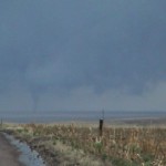
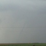
We went back down the road we came north on to highway 24 and back east toward Hoxie as a supercell was passing just to our east. It wasn’t but a few miles down the road that a cone tornado to our north became evident in the poor contrast. Eventually it exposed itself more and we were able to film it roping out several miles to our north. Of course this was the time that we came across the damage path it caused about four miles west of Hoxie and our chase was brought back to a stop again. Power lines were keeping anyone from getting by and we were left again looking for a way around. Another nice farmer told us that there are NO roads west of Hoxie that would allow us to get north without getting stuck, and we went back west/south and east to get back into Hoxie. These roads were not that much better and there were several times that we thought we would end up in the same shape as before. We made it through and over to Hill City where a large, wrapped up mesocyclone passed just west of the city. I’m convinced that something was happening there, but we were never able to see anything for sure.
After watching a stream of fire/ems and police head north of Hill City, we moved south to WaKeeney to get fuel and watch yet another strong, wrapped up and hidden mesocyclone move over. This one caught us as we were trying to escape to the east on I-70. Winds to 70+ and extremely heavy rain made the driving dangerous, but all I wanted at that time was to get the hell out of the way and be done with the day. We watched one final storm after dark form south of Wakeeney and track to our northwest before heading back into Hays where we crashed for the night. We spent two hours telling stories before bed. Two tornadoes were cool, but they were the last things that were mentioned. If anyone was wondering what Kansas mud looks like, all you had to do was look at my feet. I’m sure some of it was still there for several weeks.